
The first footpath in the village it incorporates footpath numbers ED5 and ED6, where the path to Monks Court is ED5, and the Hay Bridge side is ED6. Footpath ED5 starts at the road bridge that goes over the River Arrow, to Monks Court, the ancient mound on the north west side of the village. Unfortunately that is as far as the footpath can take you at the time of writing.
The footpath used to connect the heart of the village to the old ford in Broome Lane (now Hay Bridge) and followed the course of the River Arrow on the north bank through Arrow Bank Caravan Park. Unfortunately it is no longer usable. A flood swept away a stile in 2001 and Herefordshire Council has never replaced it. The footpath had been eroded by the river in several places which meant that its original route had changed considerably from its marked position on the map. The permissive rights were also revoked by the then landowner to prevent the public from walking through the park.
The other end of the footpath at Hay Bridge (ED6) has been partially (and rather bizarrely) reinstated by Herefordshire Council (where the old ford used to be) and runs for less than 100m into Arrow Bank Caravan Park, but no further.
What used to be a lovely walk through an attractive part of the village can no longer be enjoyed by visitors or residents.
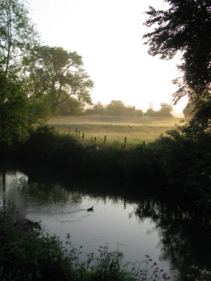
Monks Court
The second footpath (ED7) takes you across some fields to the weir and further on to Pembridge. Well worth a walk on a fine day. The footpath starts in the middle of the village opposite the Old Post Office, a black and white building which is now a private residence. From the White Swan Inn walk west on the pavement along the north side of the main road. After 100m you'll notice a gate beside a driveway entrance. Cross the gate into a small field and the walk to the weir is about 10 minutes.
If you wish to walk on to Pembridge the path is well trodden and marked by yellow arrows on the stiles. It is a three mile walk and very flat but can be muddy - so the appropriate footwear is recommended.

Walk to Pembridge
The third footpath in the village starts at the Car Park and takes you past the Church of St Mary, the Village Hall and the Bowling Green and recreation ground. Once you have left the recreation ground the footpath splits off to the left through a gate into a large open field. Here you will see the magnificent Eardisland Oak.
The footpath continues towards and between Rhydimoor and Patslie coppices, via a new bridge over a ditch, up along a hedge line and turns to the West (now ED3) joining up with Burton Lane at Home Farm. At this point there are 2 choices: either to continue across Burton Lane skirting around Home Farm, now on path ED1B, to cross the A44 at Fairview ( NB marked on the OS map as Quebeck cottage) and continue towards Dilwyn, some 3 miles further on, or to return to the village by following Burton Lane downhill in a Northerly direction for approx 200m, and rejoining path ED1A at the kissing gate on the right and walking across a field back to the village recreation ground.
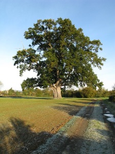
Eardisland Oak
Other Footpaths from Eardisland
There are two other footpaths (KL21 & ED9) that can be walked from Eardisland. One is circular, the other not, but they are both worth exploring.
To access these footpaths you have to walk north for half a mile down Lyme Lane. The lane starts at the Staick House (one of Eardisland's oldest and most distinctive black & white buildings), 15m east of the road bridge along the main road on the north side of the River Arrow.
Walk up the lane for half a mile and just before the private driveway entrance to Hinton Manor there is a footpath sign to your right. Walk this path for a mile or so till you come to Street Farm. From here you can either walk on to Kingsland via the private driveway that leads from Street Court or, just by the entrance gateway to Street Farm, you have the choice of taking the bridle path ED9 to Shobdon. This path passes over the old Leominster to Kington railway line. The path proceeds past Ox House Farm, skirts the southern edge of Shobdon village and eventually takes you all the way round via Shobdon Aerodrome back to Broome Lane finishing at The Broome (farm). You can then walk back to Eardisland down the lane. The walk is approximately 6-7 miles in total.

